Wendell, Idaho
April 21-27, 2017Thousand Springs State Park
Thousand Springs State Park includes several units: Malad Gorge, Kelton Trail, Earl M. Hardy Box Canyon Springs Nature Preserve, Billingsley Creek, Ritter Island, Crystal Springs and Niagara Springs.
Malad Gorge
Malad Gorge is a 250-foot-deep canyon cut through ancient lava flows by the Malad River,
downstream from a 60-foot waterfall
"Devil's Washbowl" in Malad Gorge
Gopher snake #1 on the Malad Gorge pathway
Malad River on the Kelton Trail
Kelton Road offers
views of the abutments for the bridge that carried wagons traveling the Oregon
Trail. From about 1864 to 1883 this was on the regular route that carried mail,
freight and passengers between Boise and the railhead at Kelton, Utah.
River Trail at the Ritter Island unit of Thousand Springs SP
Picturesque trail with lots of waterfalls
Ancient lava flows along the River Trail
Crystal clear water (see the fish)... Dave wished he had his fishing pole!
Views of the cliffside along the River Trail (zoom in for waterfalls)
We hiked the River Trail as far as the old Payne Lewis Ferry crossing building
along the Snake River
along the Snake River
And another gopher snake #2 on the trail
(it was a sunny warm day; perfect for snake sightings...ugh)
(it was a sunny warm day; perfect for snake sightings...ugh)
Niagra Springs (unit of the Thousand Springs SP)
Tumbling down the canyon side at 250 cubic feet per second, the churning water is the icy blue of glaciers. The springs are a National Natural Landmark.
The Niagra Springs park drive into the 350-foot-deep canyon with waterfalls along the way.
American White Pelican
American White Pelican
Thousand Springs from across the Snake River
Perrine Bridge in Twin Falls
Brave people base jump off the bridge
(you can see a little shock of red in this pic...that's a jumper)
(you can see a little shock of red in this pic...that's a jumper)
There he is!
The excitement doesn't end with the jump!
The jumpers then climb up the cliff wall to get back to the top.
Kayak launching station in Centennial Park
Another waterfall view from Centennial Park
Shoshone Falls
aka the Niagara of the west
The 212-foot-high Shoshone Falls on the Snake River was flowing even higher than normal, because the Bureau of Reclamation released more water than normal from Upper Snake River reservoirs as a flood-control measure.
This lookout area is a little scary if you don't like heights.
Even Dave was a little bit scared when he was standing on the lookout bridge.
Lookout bridge and falls
We hiked the Canyon Rim Trail to get better views.
View down the river
Hole in the canyon wall. Marmot on the bridge if you look closely.
A place to sit and view the falls from above.
The ruts made by the covered wagons can still be seen
The wagon ruts going up the hill
Another waterfall view from Centennial Park
Shoshone Falls
aka the Niagara of the west
The 212-foot-high Shoshone Falls on the Snake River was flowing even higher than normal, because the Bureau of Reclamation released more water than normal from Upper Snake River reservoirs as a flood-control measure.
This lookout area is a little scary if you don't like heights.
Even Dave was a little bit scared when he was standing on the lookout bridge.
Lookout bridge and falls
We hiked the Canyon Rim Trail to get better views.
View down the river
Hole in the canyon wall. Marmot on the bridge if you look closely.
A place to sit and view the falls from above.
Oregon Trail Overlook
Map of the Emigrant Trail and Oregon Trail
The wagon ruts going up the hill
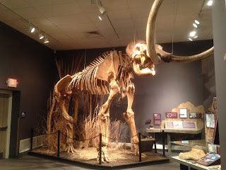
Herrett Center for Arts & Science
The Center collects, preserves, interprets, and exhibits anthropological artifacts and natural history specimens with an emphasis on the prehistoric American continents.


No comments:
Post a Comment