May 2, 2016
We left Three Rivers this morning for Red Rock Canyon
State Park. We chose Red Rock as a half-way point on our way to Death Valley.
We’re trying something new to see how it goes…we’re not making reservations for
a while. We got to Red Rock at around 1 and we were able to pick the site we
wanted (the campground says a maximum of 30’ is all that the campground could
accommodate) and could fit our rig into. There were many sites that could
accommodate our rv (35.5 ft.) and jeep so we picked the most level site and set
up camp.

Drive to Red Rock Canyon

It was kinda cool to see our rig driving through the desert

A guy on a motorcycle must've liked the rig too.
He followed Dave through the desert with a GoPro.

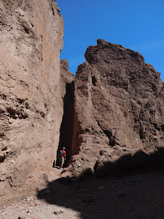
This is a beautiful campground and the sites are set
right in the
rock formations so the views are amazing.
There were only a
handful of campers there so it felt like we had the whole place to ourselves.
We decided to just relax and enjoy the views.

Our oasis in the desert

View of the park from the rocks
We grilled some burgers for
dinner and had a weber grill fire up near the rocks. The sky was beautiful and we
both luckily saw the same shooting star.

Peace and solitude

Of course, Dave had to climb the rocks the next morning.
We actually contemplated spending another night here,
but then we started reading about Death Valley and got excited to move on so we
could see everything there is to see.
May 3, 2016
We
headed out for Death Valley NP at 10:30 and arrived at Furnace Creek campground at around 2.
The entire drive there, we passed one store (a convenience store) where we could pick up a few groceries and water.


We were able to pick our campsite here as well so we
drove the jeep around the campground to find an ideal spot. We chose a full
hookup pull through for $30/night. We had originally planned on going with no
hookups since we will probably only stay three nights, but once we felt the 100+
degree temps, we opted for full hookups so we could run the AC. We're wimps.


The entire drive there, we passed one store (a convenience store) where we could pick up a few groceries and water.

Nothing but desert...

for three hours.

Our pull thru site was huge!

The day we arrived. The bar on the right states 190 feet below sea level.

The next day. Its just a little bit hot.

Ugh
The Visitors Center is right next door to our
campground so, as usual, we headed there for info and maps. After talking to a
ranger and collecting our maps, we watched a 20-minute movie on the park and
then visited the attached Death Valley Museum.
We went back to the campground, made dinner, and then
went to Zabriskie Point to watch the sunset. One thing we have learned about
the mountains is the sunsets are sometimes more spectacular in the opposite
direction! Beautiful vistas in every
direction.


At the top of Zabriskie Point. You can see our jeep in the lot below.
The mountains looked beautiful all lit up.

Sunset in the opposite direction
Then back to the campground to enjoy the night sky.
Death Valley is listed as an international dark sky park and with no moon
tonight the stars were amazing!
May 4, 2016
We got out the door at 9 this morning. Hoping to see a
few things before it got too hot. Haha. Nine was not early enough!! But we
forged ahead anyway. We started at Badwater Basin since that is below sea level
and noted as the lowest point in North America with an elevation of 282 ft below
sea level. The basin is a surreal landscape of vast salt flats.


Nothing but salt for miles

Sign up on the cliff

If you zoom in, you can see the sign above Dave's head on the left.

Here's the "badwater"
Next we headed to Natural Bridge Canyon. We were able
to park and take a one-mile uphill trail to the namesake of the canyon. A
little further up the canyon was a dry waterfall. This canyon and others like it have 50 foot plus
vertical walls and show signs of incredible water erosion. That erosion takes place very infrequently
(sometimes decades) but very violently. I would not want to get caught in one when a passing storm in the
mountains lets loose a wall of mud and water, no place to hide!


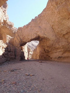


Hiking to the Natural Bridge

The walls are closing in

Dave standing under the bridge

Dave taking a shower in the dry waterfall
A little way down the road we stopped at the Devil’s
Golf Course – an immense area of rock salt eroded by wind and rain into jagged
spires. So incredibly serrated that “only the devil could play golf on such
rough links.”


Fore!

There was a loose piece by the sign. He's in geology heaven...again.
We got back in the jeep for a ride through Artist’s
Drive – A scenic loop drive through multi-hued volcanic and sedimentary hills.
Halfway through the drive you arrive at Artist’s Palette, which really does
look like an artist’s palette with mixes of reds, yellows, browns, blues and
greens.


Just take this roller coaster through the mountains and you arrive at Artist's Palette

What it looks like in real life

What it looks like on the sign

It really was pretty though...especially the blues.
A breeze (hot wind) started picking up at around this
time (1:00) so we went back to the RV to close our awnings and take a break
from the heat. At around 4 we headed back out to do more site-seeing.
We started by driving through Twenty Mule Team Canyon, a 2.8-mile one-way dirt
road that leads into and across a picturesque Death Valley landscape of canyons
and badlands.


Bye Dave

This drive was fun in the jeep

A couple doing a photo shoot in the canyon
Next we drove to Dante’s View, known as the most breathtaking
viewpoint in the park. The mountaintop overlook is more than 5,000 feet above
the floor of Death Valley and offers panoramic views. Below is Badwater Basin,
the lowest point in North America and across the valley is Telescope Peak, the
highest point in the park at 11,049 feet above sea level. We parked in the lot
and walked the trail that extends north. It was about 20 degrees cooler up here (ahhh) and very windy! The views were amazing!


Last 1/4 mile 15% grade

Dante's View

The sun shining through the clouds on Badwater Basin

The sun acting like spotlights
We got down the mountain at around 6 and headed for
Golden Canyon for sunset views of the canyon. Since it was late, and sunset is
at 7:30, we decided to only hike 1 mile in and out instead of doing the 4-mile
loop trail. It’s also still in the 90’s so too hot to hike for long. We followed the main wash uphill toward Red Cathedral and Manly Beacon. The sun setting on the rocks made the canyon look like gilded gold. Really beautiful!


The sides of the canyon are made up of red mudstone and colorful mosaic conglomerates.

Broken pavement is also visible in some spots as there was once a road
through the canyon until a rainstorm washed it out in 1976.

The rock looked beautiful as the sun was setting - it really looked like gold.


Red Cathedral in the background
We got back to the rv at 8 and heated up leftovers for
dinner.
May 5, 2016
Got up at 5:30 this morning so we could get some
site-seeing done before it heats up too much. We were able to get on the road
by 7 and headed for Harmony Borax Works; a ¼ mile walking trail through the
ruins of the borax works. The Harmony Borax operation became famous through the
use of 20 mule teams that moved borax from Death Valley to nearby communities.


Harmony Borax Works marker

Borax, the valley's most profitable mineral

Harmony Borax Works ruins


Mule Team Wagon
From there we drove through Mustard Canyon on our way
to the Salt Creek Interpretive Trail which is a 1-mile long boardwalk loop
along what would be considered a pitiful creek anywhere outside of Death
Valley. The salt stream is home to the Salt Creek Pupfish, a unique and bizarre
creature that can survive in these harsh conditions.


Mustard Canyon looked like Grey Poupon

There is water in Death Valley

We saw tons of pupfish, but they were really
hard to photograph - they're small and fast.

There's a pubfish in the left center of this picture.
Next we headed to the Ubehebe Crater, a maars volcano
that was created by a phreatic eruption two to seven thousand years ago. Hot
magma converted groundwater into steam, which created an intense pressure and
an intense explosion. The result was a half-mile wide crater surrounded by a
large cinder field. When we got to the parking lot for the crater and stepped out
of the car, the wind almost knocked us off our feet…there must have been gusts
up to 20-30 mph. Wendy took pictures from the parking lot viewing area, but
Dave braved the wind for the two-mile hike around the crater rim.


Dave on the rim of the crater


The bottom of the crater
We ate our packed lunch here and then headed back to the campground. Looks like a storms brewing tonight. Dark clouds are starting to move in and the wind is picking up.

Dave watching the storm roll in

Dave running in from the rain and wind
I'm glad you're having fun. We hope to leave in July for South Dakota. We don't know where we're headed after that.
ReplyDelete