April 28, 2016
Left Groveland today and heading for Kaweah Park
Resort in Three Rivers, CA; just outside of Sequoia National Park. It took us
about 4 hours to make the drive. The first half was through curvy mountain
roads…again. The park is beautiful and as the town name implies, there are three rivers that meet together right in the campground. The Kaweah River and, I believe, its North and South Forks. The rivers are running high so the sound of rushing water can be heard throughout the park. We walked around the campground and the length of the river within the park. They have a couple of horses in the park who wanted our attention, so we went over and said hi to them.

The curvy mountain roads that took us to our campground

Our campground is in Three Rivers, CA...this is where the three rivers meet.

We loved this campground, but its a little off the beaten path
unless you're visiting the National Parks

We didn't know they had horses at the campground until we heard this guy
doing everything to get us to come over and say hi.
Grilled some chicken and since they don’t offer fire
pits in our section of the campground, we built a small fire in our little
Weber grill and enjoyed the night sky.


Dave loves our little Weber Grill fire pit!
April 29, 2016
Got up early to head to Sequoia National Park. The
entrance to the park is only about 10 minutes from our campground. It was a
beautiful day (sunny and 70’s) in Three Bridges, but a little overcast and cold
(in the low 50’s) in the mountains.


We stopped in at the Foothills Visitors
Center to get maps and some advice on what to see and do. We drove the twisty
turning scenic (sometimes terrifying) road to the Giant Forest Museum to learn
about the Sequoias and get a trail map. We started our visit to the Giant
Forest with the Beetle Rock trail which gave us nice views of the area.

Then we walked the Big Trees trail (1 mile). The trees make you feel like you’re in a fantasy land…something you’d see in a movie.


Entrance to the park

View of the snow covered Sierra mountains.

Weather board at the Visitor's Center

Its pretty cold up here in the mountains - Beetle Rock
Then we walked the Big Trees trail (1 mile). The trees make you feel like you’re in a fantasy land…something you’d see in a movie.

Trees along Big Tree Trail

Feeling small among the big trees
We got back in the car to go to the Wolverton picnic
area to eat lunch (elevation 7,200 ft) in the picnic area. It was so cold
there, we ate our lunch very quickly!

Then drove to the Sherman Tree parking area to view the General Sherman Tree, the largest tree in the world.


A snowy lunch stop
Then drove to the Sherman Tree parking area to view the General Sherman Tree, the largest tree in the world.


Wendy standing in front of the General Sherman Tree

From there, we took the Congress Trail, a two-mile
loop that highlights the other largest trees in the park, The President Tree,
and the House and Senate Trees.


Wendy in the Senate

Dave in the House

The President

The hike back up to the car was a little challenging at the high altitude
Then we headed to Moro Rock. Along the way we stopped
at Auto Log and Tunnel Log.


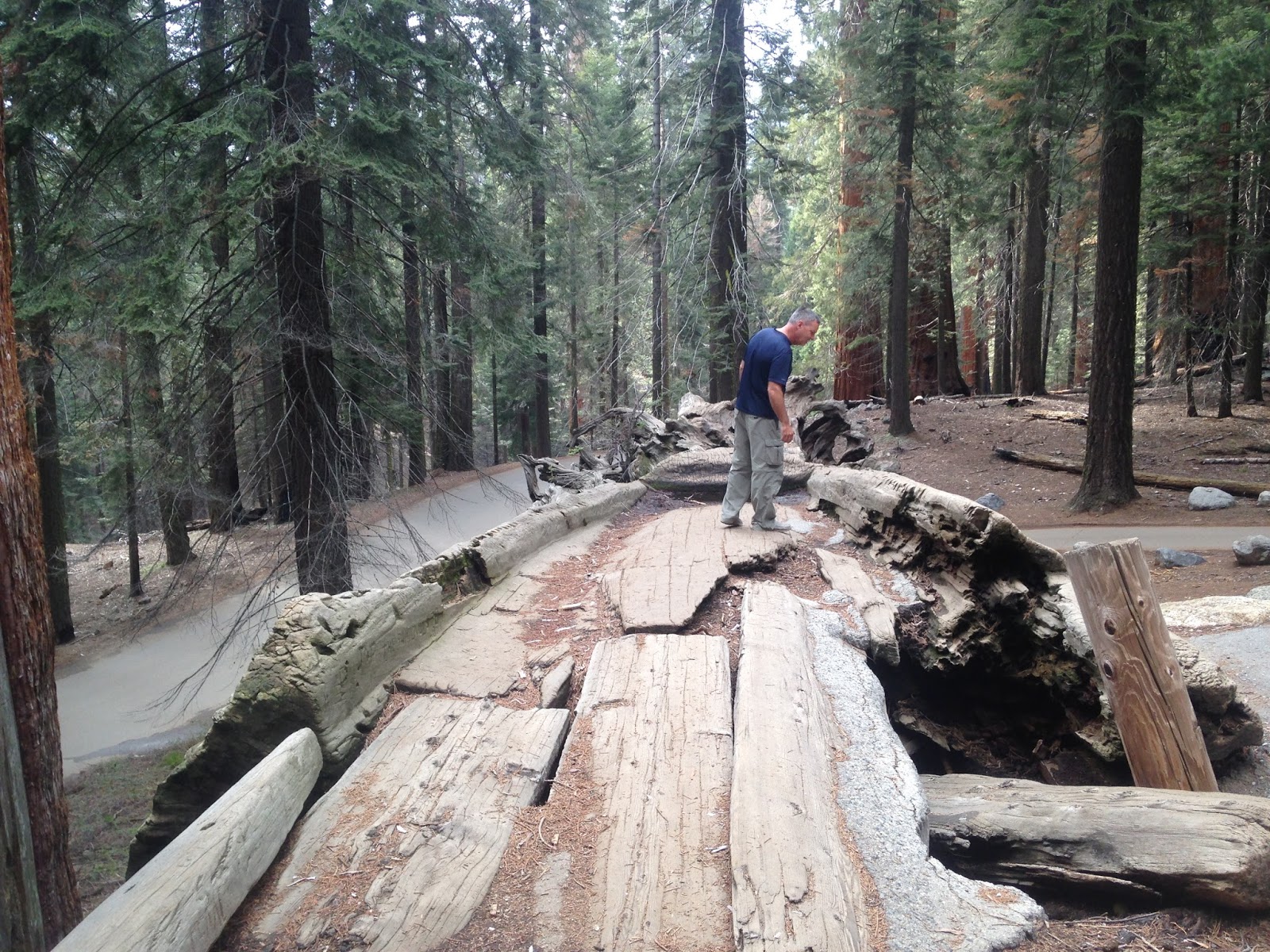
Can't believe they used to drive on this log...I'm sure it was in better shape then.


Dave driving through the tunnel log
Moro Rock is a granite dome rock formation located at
the center of the park that you can climb via a stairway (400 steps) to the
top. The 300 foot ascent takes you to 6,725 feet, about 4,000 feet above the
canyon floor. From the top you can look down on the tops of the giant sequoias.
Wendy got about ¾ of the way up and enjoyed the view from there. Dave climbed
all the way to the top and got some good photos of the area.


The beginning of the Moro Rock Trail

Halfway up

Decided to stay at this landing...

...after reading this sign at the mid-point

Dave kept going to the top

The top!!

Pretty views at the top

View of the winding roads through Sequioa NP
After the hike, we started the long drive back to the
campground from the top of the mountain. We stopped several times along the way
to get photos of the sun setting on the mountains.
Sequoia National Park is beautiful…and again, as with
Yosemite, our photos don’t do it justice.


Sun setting on Moro Rock on our drive back to the campground
April 30, 2016
Had a leisurely early morning and then got on Lake
Kaweah (a local reservoir a couple of miles downstream from our campground) at
around 11:30 to do some kayaking. It’s supposed to be in the 70’s today so we
figured we’d like to experience some warm weather for a change.


We packed lunch
so we could beach the kayaks and just hang out on the shore somewhere. There
wasn’t a lot of boat traffic when we first got on the lake…it started out a
little windy, but after lunch at around 1:30 the wind died and the boat traffic
picked up a bit.


We were really excited to see an immature bald eagle soar over our heads. So cool! Couldn’t believe how big he was, but it takes four years to reach adult plummage. By the time we got our phones out to take pics, he was a little further away.

Another cool thing that happened…a small high wing four-seater
plane (looked like an Alaska bush plane) with big fat wheels flew low and fast
right through the canyon. Still couldn’t get our cameras out fast enough to
catch a pic, but we were both kind of watching to make sure it wasn’t going to
crash into one of the mountains that he was barely skimming over. We took the
kayaks out at around 4 and went back to the campground to grill steaks for
dinner.


Lake Kaweah

It was a little windy when we first headed out, but it calmed down after a couple of hours

Stopped here for lunch

We pretty much covered most of the three square mile lake
We were really excited to see an immature bald eagle soar over our heads. So cool! Couldn’t believe how big he was, but it takes four years to reach adult plummage. By the time we got our phones out to take pics, he was a little further away.

Immature bald eagle soaring overhead
May 1, 2016
We left for Kings Canyon today at around 9:30. It was
a long drive (a little over an hour) along curvy rural roads. Passed a lot of
ranches along the way. Amazingly people live up here in the mountains. I
wouldn’t want to navigate these roads with snow and ice on them. Our first stop was the Visitor Center where we asked
one of the rangers for info and maps. With our maps in hand, we drove to
Panoramic Point overlook which is a 7,520-foot overlook of the Sierra Nevada
mountains.


Panoramic Overlook
Then we headed to General Grant Grove where we saw the
General Grant tree; the second-largest tree in the world.

Second largest tree in the world - known as the Nation's Christmas tree
We stopped for lunch
at Columbine Picnic area and then took our long scenic drive on the Kings
Canyon Scenic Byway to the bottom of the canyon. There were sooo many
opportunities to take pictures and it was a beautiful (sometimes scary) drive
down to the canyon floor. The wild flowers were in full bloom!

We're back in snow again

Wildflowers in bloom on the ride down to the canyon floor
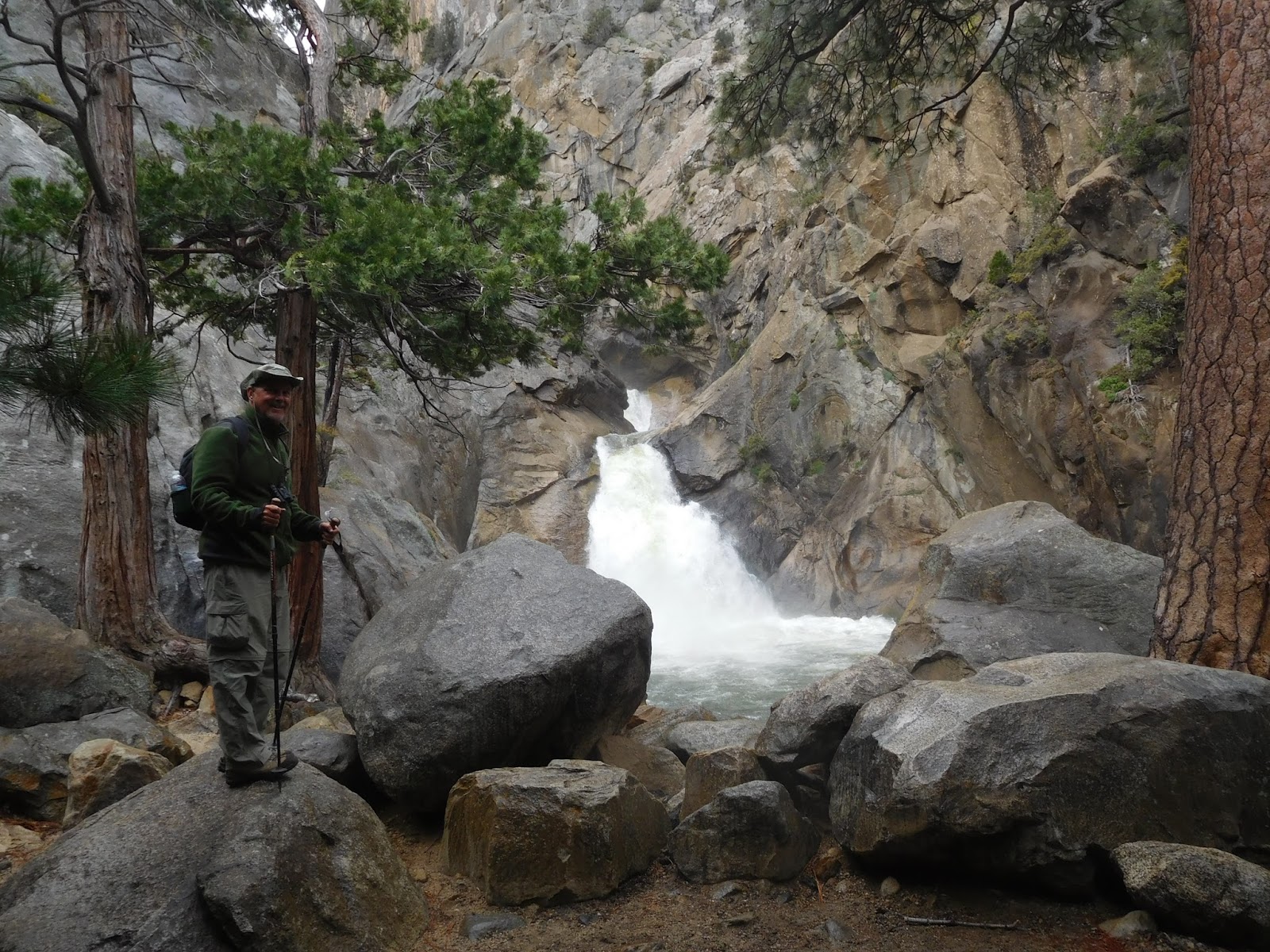
One of our stops
was at Grizzly Falls. The 75-foot waterfall was loud and forceful and at its
peak beauty due to the spring runoff. We could hear it before we even got out
of the car.

Grizzly Falls
Our destination for hiking was the River Trail to
Zumwalt Meadow Trail; a five-mile loop. The trail began right next to the
Roaring River Falls, which was really roaring!
Roaring River Falls was really roaring!
The River Trail was okay…further
from the river than we had expected, but pretty.


The River Trail wasn't always next to the river
The Zumwalt Meadow Trail was gorgeous. It started at a suspension bridge over the South Fork of the Kings River. Up canyon, beyond the river and meadow, was Glacier Monument that rises to a height of 11,165 feet. The trail climbed onto the talus slope over the meadow. The rocky trail, similar to many High Sierra trails, rose high enough for great views of the meadow, river, and cliffs. Then the trail looped around the meadow, skirting the river back to the bridge.

Suspension Bridge

Hiking through the talus slope along the trail.

The meadow with Glacier Monument in the background was beautiful!

The trail went along the river for a little bit

Wishing he had his kayak...or a fishing pole!
The sun was in and out
during our hike and toward the end it started to drizzle. Our reward for the
rain was a gorgeous rainbow with the most brilliant colors either of us has
ever seen in a rainbow!


After taking a million pictures of the rainbow, we
drove to Roads End and prepared for the long ride back to our campground. Of
course, we stopped along the way to get some sunset pictures of the canyon. Got
back to the campground at 9:30.


We're a bit behind on keeping up with the blog so we're going to try to catch up over the next few days. After visiting national parks in California and Utah, we're in New Mexico now. 
After the rain

Beauty!

The end of the road

Canyon from the bottom

Canyon from the top

That's all folks!
No comments:
Post a Comment